When getting acquainted with the chapter, prepare messages: 1. About what contributed to the creation of great powers - Assyrian, Babylonian, Persian (key words: iron, cavalry, siege equipment, international trade). 2. About the cultural achievements of the ancient peoples of Western Asia, which remain important today (key words: laws, alphabet, Bible).
1. Country of two rivers. It lies between two large rivers - the Euphrates and the Tigris. Hence its name - Mesopotamia or Mesopotamia.
The soils in Southern Mesopotamia are surprisingly fertile. Just like the Nile in Egypt, the rivers gave life and prosperity to this warm country. But the river floods were violent: sometimes streams of water fell on villages and pastures, demolishing both dwellings and cattle pens. It was necessary to build embankments along the banks so that the flood would not wash away the crops in the fields. Canals were dug to irrigate fields and gardens. States arose here at approximately the same time as in the Nile Valley - more than five thousand years ago.
2. Cities from clay bricks. The ancient people who created the first states in Mesopotamia were the Sumerians. Many settlements of the ancient Sumerians, growing, turned into cities - centers of small states. Cities usually stood on the banks of a river or near a canal. Residents sailed between them on boats woven from flexible branches and covered with leather. Of the many cities, the largest were Ur and Uruk.
In the Southern Mesopotamia there are no mountains or forests, which means there could be no construction made of stone and wood. Palaces, temples, living
old houses - everything here was built from large clay bricks. Wood was expensive - only rich houses had wooden doors; in poor houses the entrance was covered with a mat.
There was little fuel in Mesopotamia, and the bricks were not burned, but simply dried in the sun. Unfired brick crumbles easily, so the defensive city wall had to be made so thick that a cart could drive across the top.
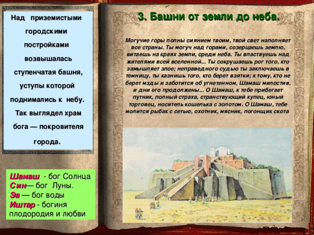
3. Towers from earth to sky. Above the squat city buildings rose a stepped tower, the ledges of which rose to the sky. This is what the temple of the city's patron god looked like. In one city it was the Sun god Shamash, in another it was the Moon god San. Everyone revered the water god Ea - after all, he nourishes the fields with moisture, gives people bread and life. People turned to the goddess of fertility and love Ishtar with requests for rich grain harvests and the birth of children.
Only priests were allowed to climb to the top of the tower - to the sanctuary. Those who remained at the foot believed that the priests there were talking with the gods. On these towers, the priests monitored the movements of the heavenly gods: the Sun and the Moon. They compiled a calendar by calculating the timing of lunar eclipses. People's fortunes were predicted by the stars.
Scientist-priests also studied mathematics. They considered the number 60 sacred. Under the influence of the ancient inhabitants of Mesopotamia, we divide the hour into 60 minutes, and the circle into 360 degrees.
| Goddess Ishtar. Ancient statue. |
4. Writings on clay tablets. Excavation of the ancient cities of Mesopotamia, art
cheologists find tablets covered with wedge-shaped icons. These icons are pressed onto a soft clay tablet with the end of a specially pointed stick. To impart hardness, the inscribed tablets were usually fired in a kiln.
Wedge-shaped icons are a special script of Mesopotamia, cuneiform.
Each sign in cuneiform comes from a design and often represents a whole word, for example: star, leg, plow. But many signs expressing short monosyllabic words were also used to convey a combination of sounds or syllables. For example, the word “mountain” sounded like “kur” and the “mountain” icon also denoted the syllable “kur” - as in our puzzles.
There are several hundred characters in cuneiform, and learning to read and write in Mesopotamia was no less difficult than in Egypt. For many years it was necessary to attend the school of scribes. Lessons continued daily from sunrise to sunset. The boys diligently copied ancient myths and tales, the laws of kings, and the tablets of stargazers who read fortunes by the stars.
 |
At the head of the school was a man who was respectfully called the “father of the school,” while the students were considered “sons of the school.” And one of the school workers was literally called “the man with the stick” - he monitored discipline.
School in Mesopotamia. A drawing of our time.
Explain the meaning of the words: Sumerians, cuneiform, clay tablet, “father of the school,” “sons of the school.”
Test yourself. 1. Who owns the names Shamash, Sin, Ea, Ishtar? 2. What do the natural conditions of Egypt and Mesopotamia have in common? What are the differences? 3. Why were stepped towers erected in Southern Mesopotamia? 4. Why are there so many more signs in cuneiform than in our alphabet of letters?
Describe the drawings of our time: 1. “Sumerian village” (see p. 66) - according to plan: 1) river, canals, vegetation; 2) huts and cattle pens; 3) main activities; 4) wheeled cart. 2. “School in Mesopotamia” (see p. 68) - according to plan: 1) students; 2) teacher; 3) a worker kneading clay.
Think about it. Why did rich people in Southern Mesopotamia indicate in their wills, among other property, a wooden stool and a door? Get acquainted with the documents - an excerpt from the tale of Gilgamesh and the myth of the flood (see pp. 69, 70). Why did the flood myth arise in Mesopotamia?
“Rivers of Eurasia” - Yangtze River. The most abundant river Russian Federation. Inland waters of Eurasia. It begins on the Valdai Hills and flows into the Caspian Sea, forming a delta. Lake Onega. Ladoga lake. Area – 17.7 thousand square meters. km, with islands of 18.1 thousand square meters. km. Ganges. Ganges (Ganga) is a river in India and Bangladesh. It begins on the Valdai Hills and flows into the Dnieper estuary of the Black Sea.
“River Geography” - Determine from the map which seas the Ob and Yenisei rivers flow into? What is a river? Determine on the map. Where do the rivers flow: Volga, Lena? River system. Let's check ourselves. DETERMINE WHICH RIVER BEGINS AT THE POINT WITH COORDINATES 57?N.L.33?E. Guess a riddle. Write the names of the rivers on the contour map. Change the letter “e” to “y” - I will become a satellite of the Earth.
“Success Channel” - How to solve the unsolvable. Ratings are given based on several parameters. A 35-minute interview between a recruiter and a real candidate for a real vacancy. In the final, the recruiter and experts give their verdict on whether the candidate is suitable for the position. Personnel decide. Channel propagation. New TV channel programs in 2011.
“Rivers 6th grade” - Where rivers look like leopards and jump from white peaks. Rivers - the main part of the land waters are lowland mountainous. Waters sushi Lesson of generalization and repetition 6th grade. L.N. Tolstoy. The fog lies on the steep slopes, motionless and deep. M.Yu. Lermontov. R. Gamzatov The Don waddles along in a peaceful, quiet flood. M.A. Sholokhov The river stretches out, flows, lazily sad And washes the banks.
“Grade 6 Geography of Rivers” - Rivers. Rivers in the works of poets. Amazon with Marañon (Southern parts of the river. Ob with Irtysh (Asia) 5451 km 6. Yellow River (Asia) 4845 km 7. Missouri (Northern Yangtze (Asia) 5800 km. Largest rivers peace. Volga (Europe) 3531 km. Nile with Kagera (Africa) 6671 km. “Oh, Volga!.. Mississippi from Missouri (North America) 6420 km. America) 4740 km. 8. Mekong (Asia) 4500 km. 9. Amur with Argun (Asia) 4440 km. 10.
“River in Kazakhstan” - The ancient name is Ya?ik (from the Kazakh Aral Sea. The ecological situation in the Ural basin continues to remain tense. There are several reasons for such concern. 2003. Before the start of shallowing, the Aral Sea was the fourth largest lake in the world. By territory In Kazakhstan, the lakes are unevenly distributed.
Ancient Mesopotamia
Lesson Plan
1. Country of two rivers .
2. Cities made of clay bricks .
3. Towers from earth to sky .
4. Writings on clay tablets .
Dunaeva L.N.
Starogolskaya Secondary School
Novoderevenkovsky district
Oryol region

It lies between two large rivers - Euphrates And Tiger.
Hence its name - Mesopotamia or Mesopotamia.
1. Country of two rivers.
A detachment of foreign warriors approached a large deep river. This was the Euphrates. The strangers looked at the running water, waved their hands in surprise and shouted: “It can’t be! But this is a river flowing in reverse!”
Guess what nation the foreigners belonged to.
Why did they call the Euphrates "the great inverted river"?
What was the name of the king who led the army to the banks of the Euphrates?
The answer is on the first flyleaf of the textbook

1. Country of two rivers.
Fill out the table based on working with the text of the textbook (clause 1, 2 § 13)
Comparison lines
Comparison lines
Comparison lines
Mesopotamia
Natural conditions
Natural conditions
Mesopotamia
Mesopotamia
Natural conditions
Infrequent rains, irregular and violent floods of the Tigris and Euphrates; the hot sun, turning the earth into a desert; marshy areas; lack of forests
Egypt
Egypt
Organization of irrigation system
Organization of irrigation system
Egypt
Organization of irrigation system
Construction of canals, reservoirs, embankments, dams and dams; use of water-lifting machines and pumps
Lack of rain; the hot sun, turning the earth into a desert; regular floods of the Nile, bringing fertile silt; fertile lands suitable for farming, located along the river
Construction of canals, use of shadufs to raise water

Describe the pattern of our time (p. 66)
according to plan
"Sumerian Village"
1) river, canals, vegetation; 2) huts and cattle pens; 3) main activities; 4) wheeled cart.
3. Towers from earth to sky.
Above the squat city buildings rose a stepped tower, the ledges of which rose to the sky. This is what the temple of the city's patron god looked like .
The mighty mountains are full of your radiance, your light fills all countries. You are mighty above the mountains, you contemplate the earth, you soar at the ends of the earth, among the sky. You rule over the inhabitants of the entire universe... You crush the horn of the one who plots evil; you imprison an unjust judge, you execute the one who takes bribes; to the one who does not take bribes and cares for the oppressed, Shamash is merciful, and his days are prolonged... O Shamash, a traveler full of fear, a wandering merchant, a young man, comes running to you merchant, bearer of a purse of gold. O Shamash, a fisherman with a net, a hunter, a butcher, a cattle driver prays to you
Shamash - Sun God
Syn - god of the moon .
Ea - god of water Ishtar - goddess of fertility and love
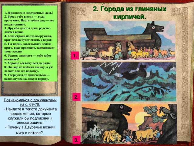
2. Cities made of clay bricks.
1. I was born on an unlucky day!
2. Throw you into water - the water will go rotten. Let you into the garden - all the fruits will rot.
3. Friendship lasts a day, kinship lasts forever.
4. If a country is poorly armed, the enemy will always be at the gates.
5. You go to conquer the enemy’s land, the enemy comes and conquers your land.
6. The poor man borrows - he makes trouble for himself!
7. A well-dressed person is always welcome.
8. He hasn’t caught the fox yet, and he’s already making a block for her.
9. I dodged a wild bull and ran into a wild cow.
Let's get acquainted with the documents on p. 69-70.
Find sentences in the text of the document that would serve as captions for the illustrations.
Why did the flood myth arise in Mesopotamia?

4. Writings on clay tablets
Cuneiform - This is a special letter from Mesopotamia.
INSCRIPTION
ON GLINYANAYA
PLATE,
DONE
STUDENT
IN SUMERIAN
SCHOOL
In the house of signs, the overseer reprimanded me: “Why are you late?” I was scared, my heart was beating wildly.
Approaching the teacher, I bowed to the ground. The father of the house of signs asked for my sign. He was dissatisfied with it and hit me.
Then I struggled with the lesson, struggled with the lesson.
When the teacher checked the order in the house of tablets,
The man with the reed stick reprimanded me:
“You have to be careful on the street: you can’t tear your clothes!”
And he hit me. Father of the House of Plaques
placed a sign with writing on it in front of me; The class supervisor ordered us: “Rewrite!” I took my tablet in my hands and wrote on it, but there was also something on the tablet that I did not understand, that I could not read. Then the warden reprimanded me: “Why were you talking without permission?”
And hit me; The caretaker said:
“Why did you bow without permission?” - and hit me;
The person keeping order said: “Why did you stand up without permission?” - and hit me; The gatekeeper said, “Why did you leave without permission?”
And hit me; The man with the stick said:
“Why did you extend your hand without permission?” - and hit me... I was disgusted with the fate of the scribe, I hated the fate of the scribe.
- Think about whether the relationship between the teacher and students in the scribe school was similar to the relationship between father and sons?

4. Letters on
clay tablets
Describe the picture of our time according to plan
"School in Mesopotamia"
- students;
2) teacher;
3) worker kneading clay

Consolidation of knowledge and methods of action
- Perform testing (option 1, 2).
- Work on cards 1, 2.
Why did rich people in Southern Mesopotamia indicate in their wills, among other property, a wooden stool and a door?


Information
about home
task
- Study § 23. Answer questions 1-4 orally.
- Write a letter to your friend from this country and share your impressions.
- You can send a photo (drawing) about Mesopotamia.
- Complete tasks 46, 48, 56 in the workbook
Plan:
- Introduction
- 1 Sumerians
- 1.1 Language
- 1.2 Writing
- 2 History
- 2.1 I Early Dynastic period (c. 2750-2615 BC)
- 2.2 II Early Dynastic period (c. 2615-2500 BC)
- 2.3 III Early Dynastic period (c. 2500-2315 BC)
- 3 Culture
- 3.1 Architecture
- 3.2 Literature
- 3.3 Religion
- 4 Rulers
- 5 Bibliography Notes
Introduction
Coordinates: 33°03′00″ n. w. 44°18′00″ E. d. / 33.05° N. w. 44.3° east d.(G) (O)33.05 , 44.3
Sumer- a civilization that existed in the southeast of Mesopotamia in the 4th-3rd millennia BC. e.
1. Sumerians
The Sumerians are a people who inhabited the Southern Mesopotamia (the area between the Tigris and Euphrates in the south of modern Iraq) at the dawn of the historical period. The Sumerians invented cuneiform writing. The Sumerians also knew the technology of the wheel and baked brick.
1.1. Language
The Sumerian language has an agglutinative structure. His family connections have not been established at this time; A number of hypotheses are being developed. The most plausible of them is the connection with the Proto-Armenian language [ ] and Aramaic [ source?] .
1.2. Writing
The oldest known writing system is the Sumerian script, which later developed into cuneiform. Cuneiform is a writing system in which characters are pressed with a reed stick (stylus) onto a tablet of wet clay. Cuneiform spread throughout Mesopotamia and became the main writing system of the ancient states of the Middle East until the 1st century. n. e. The Sumerian writing system is verbal-syllabic. It is based on a polysemantic ideogram and an additional sign expressing the connection with a specific sound element. A wedge-shaped icon captures some general concept (find, die, sell), and the system of additional icons is uniquely tied to the designation of a certain class of objects. For example, there is an icon indicating a predatory animal: When using it in any text using icons, the author indicates that it was a specific predatory animal: lion ↓↓ or bear.
Thus, in the Sumerian writing a certain system of icons appears, which have a relatively strict fixation.
2. History
In the second half of the 4th millennium BC. e. Sumerians appeared in southern Mesopotamia - a people who in later written documents call themselves “black-headed” (Sumerian “sang-ngiga”, Akkadian “tsalmat-kakkadi”). They were a people ethnically, linguistically and culturally alien to the Semitic tribes who settled Northern Mesopotamia at approximately the same time or somewhat later. The Sumerian language, with its bizarre grammar, is not related to any of the surviving languages. They belong to the Mediterranean race. Attempts to find their original homeland have so far ended in failure. Apparently, the country from which the Sumerians came was located somewhere in Asia, rather in a mountainous area, but located in such a way that its inhabitants were able to master the art of navigation. Evidence that the Sumerians came from the mountains is their way of building temples, which were erected on artificial embankments or on terraced hills made of brick or clay blocks. It is unlikely that such a custom could have arisen among the inhabitants of the plains. It, along with their beliefs, had to be brought from their ancestral homeland by the inhabitants of the mountains, who paid honor to the gods on the mountain peaks. And another piece of evidence is that in the Sumerian language the words “country” and “mountain” are written the same way. There is also a lot to suggest that the Sumerians came to Mesopotamia by sea. Firstly, they primarily appeared in river mouths. Secondly, in their ancient beliefs the main role was played by the gods Anu, Enlil and Enki. And finally, as soon as they settled in Mesopotamia, the Sumerians immediately began organizing irrigation, navigation and navigation along rivers and canals. The first Sumerians to appear in Mesopotamia were a small group of people. There was no need to think about the possibility of mass migration by sea at that time. The Sumerian epic mentions their homeland, which they considered the ancestral home of all humanity - the island of Dilmun.
Having settled at the mouths of the rivers, the Sumerians captured the city of Eredu. This was their first city. Later they began to consider it the cradle of their statehood. Over the years, the Sumerians moved deeper into the Mesopotamian plain, building or conquering new cities. For the most distant times, the Sumerian tradition is so legendary that it has almost no historical significance. It was already known from Berossus’ data that the Babylonian priests divided the history of their country into two periods: “before the flood” and “after the flood.” Berossus, in his historical work, notes 10 kings who ruled “before the flood” and gives fantastic figures for their reign. The same data is given by the Sumerian text of the 21st century BC. e., the so-called “Royal List”. In addition to Eredu, the “Royal List” names Bad Tibiru, Larak (later unimportant settlements), as well as Sippar in the north and Shuruppak in the center as “antediluvian” centers of the Sumerians. This newcomer people subjugated the country without displacing - the Sumerians simply could not - the local population, but on the contrary, they adopted many of the achievements of the local culture. The identity of material culture, religious beliefs, and socio-political organization of various Sumerian city-states does not at all prove their political community. On the contrary, it is more likely to assume that from the very beginning of the Sumerian expansion into Mesopotamia, rivalry arose between individual cities, both newly founded and conquered.
2.1. I Early Dynastic period (c. 2750-2615 BC)
At the beginning of the 3rd millennium BC. e. in Mesopotamia there were about one and a half dozen city-states. The surrounding small villages were subordinate to the center, headed by a ruler who was sometimes both a military leader and a high priest. These small states are now commonly referred to by the Greek term “nomes.” The following nomes are known to have existed at the beginning of the Early Dynastic period:
Ancient Mesopotamia
- Eshnunna. The nome of Eshnunna was located in the valley of the Diyala River.
- Sippar. It is located above the bifurcation of the Euphrates into the Euphrates proper and Irnina.
- An unnamed nome on the Irnina canal, which later had a center in the city of Kutu. The original centers of the nome were the cities located under the modern settlements of Jedet Nasr and Tell Ukair. These cities ceased to exist by the beginning of the 3rd millennium BC. e.
- Quiche. Located on the Euphrates, above its junction with Irnina.
- Cash. Located on the Euphrates, below its junction with the Irnina.
- Nippur. The nome is located on the Euphrates, below the separation of Inturungal from it.
- Shuruppak. Located on the Euphrates, below Nippur. Shuruppak, apparently, always depended on neighboring nomes.
- Uruk. Located on the Euphrates, below Shuruppak.
- Lv. Located at the mouth of the Euphrates.
- Adab. Located on the upper section of Inturungal.
- Umma. Located on Inturungal, at the point where the I-nina-gena channel separates from it.
- Larak (city). Located on the bed of the canal, between the Tigris proper and the I-nina-gena canal.
- Lagash. Lagash Nome included a number of cities and settlements located on the I-nina-gena canal and adjacent canals.
- Akshak. The location of this nome is not entirely clear. It is usually identified with the later Opis and placed on the Tigris, opposite the confluence of the Diyala River.
Of the cities of the Sumerian-East Semitic culture located outside Lower Mesopotamia, it is important to note Mari on the Middle Euphrates, Ashur on the Middle Tigris and Der, located east of the Tigris, on the road to Elam.
The cult center of the Sumerian-East Semitic cities was Nippur. It is possible that initially it was the name of Nippur that was called Sumer. In Nippur there was E-kur - the temple of the common Sumerian god Enlil. Enlil was revered as the supreme god for thousands of years by all Sumerians and Eastern Semites (Akkadians), although Nippur never constituted a political center either in historical or, judging by Sumerian myths and legends, in prehistoric times.
Analysis of both the “Royal List” and archaeological data show that the two main centers of Lower Mesopotamia from the beginning of the Early Dynastic period were: in the north - Kish, dominating the network of canals of the Euphrates-Irnina group, in the south - alternately Ur and Uruk. Outside the influence of both the northern and southern centers were usually Eshnunna and other cities of the Diyala River valley, on the one hand, and the nome of Lagash on the I-nina-gena canal, on the other.
2.2. II Early Dynastic period (c. 2615-2500 BC)
Aga's defeat at the walls of Uruk caused, it seems, an invasion of the Elamites, conquered by his father. The Kish tradition places after the I dynasty of Kish the dynasty of the Elamite city of Avan, which, obviously, established its hegemony, in addition to Elam, in the northern part of Mesopotamia. The part of the “list” where one would expect the names of the kings of the Awan dynasty is damaged, but it is possible that one of these kings was Mesalim.
In the south, parallel to the Avana dynasty, the First Dynasty of Uruk continued to exercise hegemony, whose ruler Gilgamesh and his successors managed, as evidenced by documents from the archives of the city of Shuruppak, to rally a number of city-states around themselves into a military alliance. This union united states located in the southern part of Lower Mesopotamia, along the Euphrates below Nippur, along Iturungal and I-nina-gene: Uruk, Adab, Nippur, Lagash, Shuruppak, Umma, etc. If we take into account the territories covered by this union, we can , probably, attribute the time of its existence to the reign of Mesalim, since it is known that under Meselim the Iturungal and I-nina-gena canals were already under his hegemony. It was precisely a military alliance of small states, and not a united state, because in the archive documents there is no information about the intervention of the rulers of Uruk in the affairs of Shuruppak or about the payment of tribute to them.
The rulers of the “nome” states included in the military alliance did not wear the title “en” (cult head of the nome), unlike the rulers of Uruk, but usually called themselves ensi or ensia [k] (Akkadian ishshiakkum, ishshakkum). This term apparently meant "lord (or priest) of laying structures". In reality, however, ensi had both cult and even military functions, so he led a squad of temple people. Some rulers of the nomes sought to assign themselves the title of military leader - lugal. Often this reflected the ruler's claim to independence. However, not every title “lugal” indicated hegemony over the country. The hegemonic military leader called himself not just “the lugal of his nome,” but either the “lugal of Kish” if he claimed hegemony in the northern nomes, or the “lugal of the country” (lugal of Kalama); to obtain such a title, it was necessary to recognize the military supremacy of this ruler in Nippur, as the center of the pan-Sumerian cult union. The rest of the lugals practically did not differ in their functions from the ensi. In some nomes there were only ensi (for example, in Nippur, Shuruppak, Kisur), in others only lugali (for example, in Ur), in others, both in different periods (for example, in Kish) or even, perhaps, simultaneously in some cases (in Uruk, in Lagash) the ruler temporarily received the title of lugal along with special powers - military or other.
2.3. III Early Dynastic period (c. 2500-2315 BC)
Stage III of the Early Dynastic period is characterized by rapid growth of wealth and property stratification, aggravation of social contradictions and the tireless war of all the nomes of Mesopotamia and Elam against each other with an attempt by the rulers of each of them to seize hegemony over all others.
During this period, the irrigation network expands. From the Euphrates in a southwestern direction, new canals were dug: Arakhtu, Apkallatu and Me-Enlila, some of which reached the strip of western swamps, and some completely devoted their waters to irrigation. In the southeast direction from the Euphrates, parallel to Irnina, the Zubi canal was dug, which originated from the Euphrates above Irnina and thereby weakened the importance of the nomes of Kish and Kutu. New nomes were formed on these channels:
- Babylon (now a series of settlements near the city of Hilla) on the Arakhtu Canal. The communal god of Babylon was Amarutu (Marduk).
- Dilbat (now the settlement of Deylem) on the Apkallatu canal. Community god Urash.
- Marad (now the site of Vanna wa-as-Sa'dun) on the Me-Enlila canal. Community god of Lugal-Marada and nome
- Kazallu (exact location unknown). Community god Nimushd.
- Push on the Zubi channel, in its lower part.
New canals were also diverted from Iturungal, and also dug inside the Lagash nome. Accordingly, new cities arose. On the Euphrates below Nippur, probably based on dug canals, cities also arose that claimed independent existence and fought for sources of water. One can note such a city as Kisura (in Sumerian “border”, most likely the border of the zones of northern and southern hegemony, now the site of Abu Khatab), some nomes and cities mentioned by inscriptions from the 3rd stage of the Early Dynastic period cannot be localized.
The raid on the southern regions of Mesopotamia, launched from the city of Mari, dates back to the 3rd stage of the Early Dynastic period. The raid from Mari roughly coincided with the end of the hegemony of the Elamite Awan in the north of Lower Mesopotamia and the 1st Dynasty of Uruk in the south of the country. It is difficult to say whether there was a causal connection here. After that, in the north of the country two local dynasties began to compete, as can be seen on the Euphrates, the other on the Tigris and Irnin. These were the II dynasty of Kish and the Akshaka dynasty. Half of the names of the Lugals who ruled there, preserved by the “Royal List,” are East Semitic (Akkadian). Probably both dynasties were Akkadian in language, and the fact that some of the kings bore Sumerian names is explained by the strength of cultural tradition. Steppe nomads - Akkadians, who apparently came from Arabia, settled in Mesopotamia almost simultaneously with the Sumerians. They penetrated into the central part of the Tigris and Euphrates, where they soon settled and began farming. From about the middle of the 3rd millennium, the Akkadians established themselves in two large centers of northern Sumer - the cities of Kish and Akshe. But both of these dynasties were of little importance compared to the new hegemon of the south - the Lugals of Ur.
According to the ancient Sumerian epic, around 2600 BC. e. Sumer unites under the rule of Gilgamesh, the king of Uruk, who later transferred power to the dynasty of Ur. Then the throne is seized by Lugalannemundu, the ruler of Adab, who subjugated Sumer from the Mediterranean Sea to southwestern Iran. At the end of the 24th century. BC e. the new conqueror, the king of Umma Lugalzagesi, expands these possessions to the Persian Gulf.
In the 24th century BC. e. Most of Sumer was conquered by the Akkadian king Sharrumken (Sargon the Great). By the middle of the 2nd millennium BC. e. Sumer was absorbed by the growing Babylonian Empire. Even earlier, by the end of the 3rd millennium BC. e., the Sumerian language lost its status as a spoken language, although it persisted for another two millennia as a language of literature and culture.
3. Culture
Cuneiform tablet
Sumer is one of the oldest civilizations known to us. The Sumerians are credited with many inventions, such as the wheel, writing, irrigation systems, agricultural implements, the potter's wheel, and even brewing, although it is not known for certain whether these drinks were similar in structure to later hop liqueurs.
3.1. Architecture
There are few trees and stones in Mesopotamia, so the first building material was mud bricks made from a mixture of clay, sand and straw. The basis of the architecture of Mesopotamia consists of secular (palaces) and religious (ziggurats) monumental buildings and buildings. The first of the Mesopotamian temples that have reached us date back to the 4th-3rd millennia BC. e. These powerful cult towers, called ziggurat (holy mountain), were square and resembled a stepped pyramid. The steps were connected by stairs, and along the edge of the wall there was a ramp leading to the temple. The walls were painted black (asphalt), white (lime) and red (brick). The design feature of monumental architecture was going back to the 4th millennium BC. e. the use of artificially erected platforms, which is explained, perhaps, by the need to isolate the building from the dampness of the soil, moistened by spills, and at the same time, probably, by the desire to make the building visible from all sides. Another characteristic feature, based on an equally ancient tradition, was the broken line of the wall formed by the projections. Windows, when they were made, were placed at the top of the wall and looked like narrow slits. The buildings were also illuminated through the doorway and the hole in the roof. The roofs were mostly flat, but there was also a vault. Residential buildings discovered by excavations in the south of Sumer had an internal open courtyard around which covered rooms were grouped. This layout, which corresponded to the climatic conditions of the country, formed the basis for the palace buildings of the southern Mesopotamia. In the northern part of Sumer, houses were discovered that, instead of an open courtyard, had a central room with a ceiling.
3.2. Literature
One of the most famous works of Sumerian literature is considered to be the “Epic of Gilgamesh” - a collection of Sumerian legends, later translated into Akkadian. Tablets with the epic were found in the library of King Ashurbanipal. The epic tells the story of the legendary king of Uruk Gilgamesh, his savage friend Enkidu and the search for the secret of immortality. One of the chapters of the epic, the story of Utnapishtim, who saved humanity from the Flood, is very reminiscent of the biblical story of Noah's Ark.
The Sumerian-Akkadian cosmogonic epic Enuma Elish is also known.
3.3. Religion
Sumerian goddess
The Sumerian pantheon of gods functioned as an assembly led by a god-king. The Assembly consisted of groups, the main group known as the "Great Gods" consisted of 50 deities and, according to the beliefs of the Sumerians, decided the fate of mankind. Also, deities were divided into creative and non-creative. The creative gods were responsible for the sky (An), earth (mother goddess Ninhursag), sea (Enki), air (Enlil). Cosmic phenomena and cultural phenomena were maintained in harmony thanks to the so-called “Me” (or “Me”). Me is a set of rules given to each cosmic function and cultural phenomenon, with the purpose of eternally maintaining their function according to the clans of the deity that created them. Me rules:
- enstvo
- true
- royal power
- law
- art
Man, according to Sumerian mythology, is created from clay mixed with divine blood. The Sumerians also had a myth about the global flood.
The universe in Sumerian mythology consists of a lower and upper world and the earth between them. In general, the lower world was considered a huge space underground, a counterweight to the heavens. The lower world was ruled by the gods: Nergal and Ereshkigal.
The Sumerians believed that they were created to serve the gods, and there was a very close connection between them and the gods. With their labor they seem to “feed” the gods, and without them the gods could not exist just as the Sumerians could not exist without the gods.
4. Rulers
- List of kings of Sumer
5. Bibliography
- Emelyanov V.V. Ancient Sumer: Essays on Culture. St. Petersburg, 2001 (ISBN 5-85803-161-7).
- Sumerians as the founders of world history
Notes
- Kravchenko A.I. Culturology: Study. manual for universities. - M.: Academic project, 2001.
This abstract is based on an article from Russian Wikipedia. Synchronization completed 07/10/11 01:16:59
Categories: Sumer.
Text is available under a Creative Commons Attribution-ShareAlike license.